
Exploiting state-of-the-art geostationary satellite data to investigate Asian & North American air quality
Poor air quality is one of the largest environmental stresses on human health (Cohen et al., 2017) and most severely impacts on countries with large dense populations and intense industrial/economic activities. While there has been much study and investigation into the drivers of global and regional air pollution (Lelieveld et al., 2015; Pope et al., 2018), further and improved scientific understanding is needed to help develop policies to tackle and mitigate against the harmful impacts it has on human health.
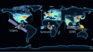
Historically, surface observations and infrequent aircraft campaigns have provided important information on air pollution, but the limited spatiotemporal coverage of these measurements have presented substantial challenges to fully understand the balance of processes leading to air pollution. In the recent decades, there has been rapid development and advancements in satellite technologies improving our ability to monitor air pollution. The most advance platforms are the South Korean Geostationary Environmental Monitoring Spectrometer (GEMS; Kim et al., 2020) and American (NASA) Tropospheric Emissions: Monitoring of Pollution (TEMPO; Zoogman et al., 2017) geostationary satellites, launched in February 2020 and April 2023, respectively. We can now monitor continental air pollution hotspots, spatial gradients, diurnal cycles and long-range transport at unparalleled spatial and temporal resolutions (Figure 1).
Combined with advanced regional and global atmospheric chemistry models, the synergy of current Earth observation and modelling capabilities allows for the robust, novel and timely investigation and quantification of key processes controlling air quality. Given the geostationary orbits of GEMS and TEMPO, and the ongoing air pollution challenges over Asian and North America, these regions represent the key scientific focus of this PhD project. The research aims of this PhD are:
- To what extent do these new geostationary platforms provide robust and important quantification of Asian and North American air pollution hotspots, spatial gradients and diurnal cycles?
- Can state-of-the-art atmospheric chemistry models simulate the observed spatiotemporal distribution of observed air pollution and help underpin the key processes driving it?
- Can a synergy of models and satellite data be used to constrain regional emission of key air pollutants?
- How do the interactions of emissions, atmospheric chemistry and meteorology contribute to the regional and hemispheric (i.e. Asian to North America) transboundary issues of air pollution?
To tackle these research questions, the student will use a combination of the geostationary satellite air quality products and atmospheric chemistry models (e.g. the global TOMCAT model (Monks et al., 2017) and/or the regional WRF-Chem model (Graham et al., 2021)). A potential outline of activities for each year could be:
Year 1: Exploring the GEMS and TEMPO air pollution data, developing skills and codes to investigate Aim 1. Gain experience running atmospheric chemistry models.
Year 2: Undertake comprehensive model-satellite comparisons to understand the model skill/deficiencies and thus improving the model’s representation of key processes and quantifying their importance to controlling air quality.
Year 3: Use the model for sensitivity experiences to constrain the regional emission inventories and understand the importance of pollution sources in Asia on Asian (local) and North American (transboundary) air quality.
The student will gain training in using large satellite data sets, running atmospheric chemistry models and translating their research results into scientific publications. The student may also be able to join in with specialised training from Research Centres (e.g. the National Centre for Earth Observation) and DTP/CDT courses on data assimilation and machine learning etc.
References:
- Cohen AJ, et al. 2017. Estimates and 25-year trends of the global burden of disease attributable to ambient air pollution: an analysis of data from the Global Burden of Diseases Study. The Lancet, 389, 1807-1918, https://doi.org/10.1016/S0140-6736(17)30505-6.
- Graham AM, et al. 2021. Impact of the 2019/2020 Australian Megafires on Air Quality and Health. GeoHealth, 5(10), e2021GH000454, https://doi.org/10.1029/2021GH000454.
- Kim J, et al. 2020. New Era of Air Quality Monitoring from Space: Geostationary Environment Monitoring Spectrometer (GEMS). Bulletin of the American Meteorological Society, 101(1), E1-E22, https://doi.org/10.1175/BAMS-D-18-0013.1.
- Lelieveld J, et al. 2015. The contribution of outdoor air pollution sources to premature mortality on a global scale. Nature, 525, 367-371, https://doi.org/10.1038/nature15371.
- Monks SA, et al. The TOMCAT global chemistry transport model v1.6: Description of chemical mechanism and model evaluation. Geoscientific Model Development, 10(8), 3025– 3057, https://doi.org/10.5194/gmd-10-3025-2017.
- Pope RJ, et al. 2018. Widespread changes in UK air quality observed from space. Atmospheric Science Letters, 19:e817, https://doi.org/10.1002/asl.817.
- Zoogman P, et al. 2017. Tropospheric emissions: Monitoring of pollution (TEMPO). Journal of quantitative spectroscopy and radiative transfer, 186, 17-39, https://doi.org/10.1016/j.jqsrt.2016.05.008.