
Translating magma intrusion into volcano deformation
Summary
Modelling volcano ground deformation driven by magma movement is critical to forecasting volcanic eruptions. However, the use of such modelling is severely limited because we assume that the host rocks around magma bodies are simple and homogeneous. In this project, we will visit the Pan de Azucar in Chile (Fig. 1A) and use seismic reflection data from offshore New Zealand (Fig. 1B) to see how rocks above ancient intrusions were uplifted and folded during magma emplacement. Geological mapping of these areas using digital techniques, and rock sample collection in Chile for rock mechanic and magnetic experiments will enable us to find where deformation concentrates above intrusions, and establish how it locally changes the behaviour of rocks during folding. With this information, we will then be able to explore how to build these complexities into volcano deformation models, helping improve the reliability of their use in eruption forecasting.
Full description
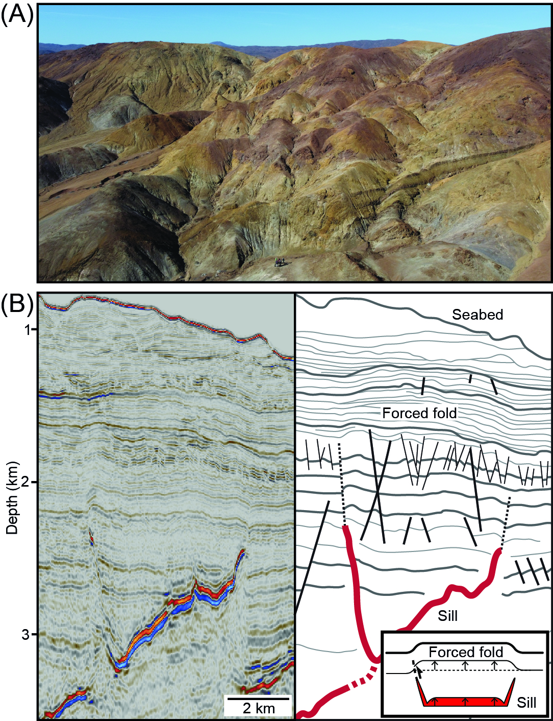
As magma moves and accumulates beneath volcanoes, it often creates room for itself by pushing up the overlying rock and Earth’s surface. This uplift produces what we call forced folds (e.g. Fig. 1B) (Reeves et al. 2018). We can monitor mm-scale ground deformation driven by such forced folding at active volcanoes using satellite- and ground-based instruments (Magee et al. 2018; Biggs and Wright, 2020). With these ground deformation data we model where the underlying magma is located, how much there is, and how fast it is moving; this information is critical to forecasting volcanic eruptions. However, the models we use typically assume magma intrudes into a rock that has a very simple structure and composition. Specifically, we model the space around magma bodies as a homogeneous, isotropic, and linearly elastic material. Yet we know rocks are heterogeneous and anisotropic at multiple scales, and that these complexities affect the amount and distribution of ground deformation. We therefore need to work out how to include these realistic rock properties into models to improve the reliability of eruption forecasts.
Objectives and methodology
We can study the forms of intrusions and their associated host rock deformation (e.g. forced folds) where they are exposed at Earth’s surface or imaged in geophysical data (e.g. Fig. 1). To improve the reliability of volcano deformation models, in this project you will examine deformation within forced folds, and benchmark how these affect mechanical rock properties. You will feed this data into new a generation of ground deformation models that account for spatial and temporal geological complexity. To achieve this aim, you will:
1) Conduct fieldwork in the Pan de Azucar, Chile (Grocott and Taylor, 2002), where you will use digital mapping techniques to constrain the style and distribution of structures within a forced fold above a granitic pluton; this will help ascertain where deformation becomes localized.
2) Perform mechanical testing in the laboratory of rock samples collected during fieldwork, which will allow you to determine how resistant rocks are to different forms of deformation. We expect that areas where deformation localizes within the uplifting rock will become weaker or stronger, depending on the type of structures formed, and that this change will affect how continued uplift is expressed at Earth’s surface.
3) Interpret seismic reflection data from offshore New Zealand where sills are overlain by forced folds that contain numerous onlapped surfaces (Fig. 1B) (Reeves et al. 2018); these surfaces mark times when the contemporaneous seafloor was uplifted by magmatism. The presence of multiple onlap surfaces indicates that the fold, and thus the underlying sill, grew incrementally over a prolong period of time. You will reconstruct the ground deformation at each onlap event and compute how ground deformation changes through time; this will be equivalent to analysing the ground deformation signal captured via satellites over timescales of 10’s to 100’s years, providing a predictive tool for what satellites we may acquire over the next century.
4) Help build new, state-of-the-art numerical models to establish how the ground deformation signal above intrusions may vary depending on host rock properties and magma emplaces through time.
Training and opportunities
You will be based in the Institute for Geophysics and Tectonics at the University of Leeds. You will be provided training in field skills, rock mechanics, seismic interpretation, and volcano deformation modelling. Additional training in scientific writing, statistics and data analysis, problem-solving, time management, and developing independent research planning skills will also be provided by us and the Panorama Doctoral Training program. Through this training, you will become a confident and independent researcher with transferable skills applicable to both academic and non-academic jobs.
Within Leeds, you will have the opportunity to interact with the Volcanology and Tectonics research clusters. The School also hosts numerous staff from the Centre for the Observation and Modelling of Earthquakes and Tectonics, with whom you will interact.
You will conduct fieldwork with Dr John Browning at Pontificia Universidad Católica de Chile in Santiago, Chile and will use their rock preparation and rock mechanic facilities. There will also be opportunity to engage with and/or help organise local science communication initiatives.
Applicant Background
This project would suit candidates with a background in geology or geophysics, and specific interests in volcanology or structural geology. We encourage applicants from all backgrounds.
Fit to NERC Science
This project constitutes fundamental research into Earth processes and therefore fits well within the remit of NERC science. The project fits into the research areas of Volcanic Processes, Geohazards, and Tectonic Processes.