
Climate resilience of vulnerable infrastructure using novel seismic monitoring methods
In this PhD, you will develop geophysical methods to monitor and assess the resilience of critical infrastructure to increasingly extreme weather events linked to climate change. The project represents an exciting blend of cutting-edge developments in seismology with real-world applications to climate resilience, for a motivated geophysicist.
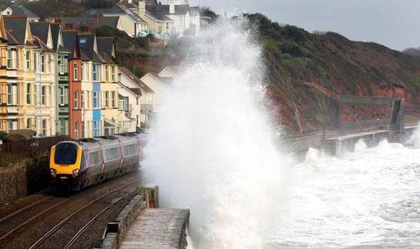
Failing coastal flood defence assets risk human life and are expensive to repair. Changing weather patterns, featuring a likely increase in drought and downpour intensity, motivate an urgent need to understand the drivers of asset deterioration and eventual failure. Deterioration can be monitored using geophysical methods: by detecting properties and processes (e.g., mechanical strength and water saturation) within the asset, and how they vary in space and time, we can assess stability. Geophysical measurements are essential to bridge gaps in data coverage between point sensor measurements (e.g., piezometers, tiltmeters, etc.) and remote sensing observations (e.g., InSAR, LiDAR, etc.).
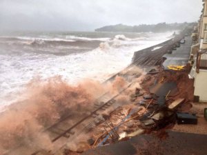
In spring 2023, a strategically important coastal flood defence in the south-west of England, was breached. This endangered the operation of the London to Penzance railway line, located 50 m from the breach location, and risked flooding ~100 properties in the area. In summer 2023, CASE partner AtkinsRéalis began work with the Environment Agency to deploy geophysical characterisation and monitoring techniques at the site, to build longer-term asset resilience and identification of potential future breach zones. Among these techniques is a British Geological Survey (BGS) time-lapse resistivity PRIME system, used to map potential seepage zones within the embankment from time-lapse resistivity measurements. Your contribution will be a seismic counterpart to this study, interpreting a novel dataset of distributed sensing data.
Distributed sensing involves monitoring the characteristics of laser backscatter within a fibre-optic cable: as the cable is deformed, either through strain or seismic vibration, the backscatter changes and the deformation can be reconstructed at high resolution. The result is a comprehensive picture of ground deformation which, when combined with electrical measurements, can inform ground movement and water accumulation – thereby providing insights that are clearly valuable for monitoring vulnerable infrastructure. The distributed sensing dataset is anticipated span winter 2024 to spring 2025, capturing the winter weather cycle when the greatest risk to infrastructure is present.
Hosted in Leeds’ School of Earth and Environment (SEE), this PANORAMA project includes, but is not limited to:
i) interpretation of distributed sensing methods, in terms of the seismic and strain evolution at the site;
ii) development of data science approaches to handle and interpret large volumes of strain/seismic data;
iii) integration of your observations with other datasets (e.g., electrical and conventionally-sensed seismic data, remotely-sensed imagery, time-lapse resistivity) to provide a comprehensive assessment of infrastructure stability at the site.
There are many ways that these datasets could be analysed. Could nearby train vibrations serve as a seismic source? Could an ‘early warning’ trigger protocol be developed through a machine learning framework? You should discuss your ambitions with your project supervision team but, whichever direction you take, you will be supported by expert advisors. These include staff from SEE and BGS, and a steering group comprising the CASE partner AtkinsRéalis, the Environment Agency and distributed sensing developer Febus Optics. Placed at the cutting-edge of engineering geophysics, your work will have many avenues for publication through journal articles and conference dissemination, and you will be supported in developing these skills. You can also access SEE’s sector leading stock of geophysical instrumentation, to design your own field surveys and develop as a field geophysicist. CASE support from AtkinsRéalis also leverages a placement with their geophysics team, to gain additional experience beyond the scope of your PhD, and an additional contribution to your PhD training grant.
Applicant background: You should be experienced in geophysics or a related discipline (e.g. geology, physics, computer science, civil engineering/geotechnics), ideally with experience of seismic data analysis and computer programming. You should have a passion for the translation of geophysical theory into practical applications with industrial and societal relevance. With guidance, you will be able to bring your own ideas and innovations to the analysis of your datasets. Fieldwork is an option during this project and you may develop your own test applications for distributed sensing, all adhering to health and safety best-practice. We welcome interest from those with industrial and/or academic experience.