
Earth’s Small-Scale Structure – Big Data and Machine Learning
Summary
The interior of the Earth holds the record of the evolution of the planet and the imprint of ongoing processes. Lithospheric material is transported into the deep interior through subduction and then distributed throughout the mantle by convection. Core and mantle exchange heat and material, leading to partial melting and compositional heterogeneity in the lowermost mantle and uppermost core. Continent-sized structures (Large Low Velocity Provinces – LLVP) have been mapped in two near-antipodal locations along the equator and have been shown change location and shape in response to mantle convection mainly controlled by subduction linking the surface of the Earth to the deep mantle. In turn, Large Low Velocity Provinces potentially control the location of intraplate volcanism and flood basalts, and influence the dynamics of the core creating the Earth’s magnetic field. Understanding these structures, their origin, composition, and evolution are essential to understand our planet’s evolution to its current habitability.
This project will use the huge amount of seismic data collected in the last decades together with machine learning approaches (Arrowsmith et al., 2022, Kong et al., 2019) to better resolve some of the structures in the lowermost mantle with an aim to produce global maps of mantle heterogeneity structure.
Seismic waves emitted by earthquakes and recorded by seismometers at Earth’s surface are one of the few probes available to image the Earth’s deep interior. Using the detailed information contained in these data allows mapping out the structures in the deep Earth. Mapping the Earth’s interior has been hampered by the uneven distribution of seismic stations and earthquake sources. The large increase of station deployments in the last decades and the related increase in available seismic data now opens an opportunity to move away from the analysis of seismic data in regional studies to using the available massive seismic datasets to gain global insight into the structure of the Earth’s deep mantle. To handle these large datasets modern machine learning approaches are necessary and will be a core component of this project.
This project aims to gain better insight into the distribution and structure of small-scale structures (with scalelengths of tens of km) in the deep Earth. We will use seismic timeseries datasets stored at international data centres and will target specific areas of the seismograms most sensitive to the structure of the deep Earth. Machine learning will be employed for data quality control, signal characterization and zonation. Using a combination of different probes for deep Earth structure we will be able to resolve a host of structure and infer their dynamical links, shared origins, and composition.
Wider Impact
The Earth is the only habitable planet in the solar system. The key to understand how our planet has developed to support life lies in the deep Earth. The Earth’s surface and atmosphere is inherently linked to processes deep in the Earth’s interior through material and heat fluxes. Although the larger structures such as LLVPs and subducted slabs are well imaged using seismic tomography important processes such as carbon and water transported into the deep Earth, core mantle reactions and compositional mixing are processes that cannot be resolved using traveltime tomography but rely on careful analysis of seismic waveforms. This project aims to understand some of the features utilising global datasets.
Aim of the project
Many of the features imaged in the deep Earth are ill-understood and are at the limit of seismic resolution. Here we will target :
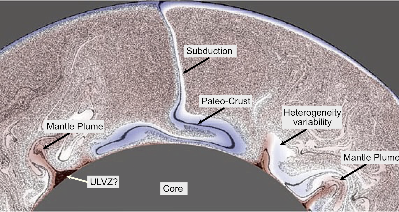
Ultra-Low Velocity Zones (ULVZs): ULVZs are thin (tens of kms) layers with strongly reduced seismic velocities and potentially increased density (Yu and Garnero, 2018). Their typical lateral extend is on the order of hundreds of kilometres and they are located at the core-mantle boundary. ULVZs are of unknown origin and both partial melt and compositional origins are discussed. They might have strong influence on core-mantle interactions and mantle plume stability and have been linked to the remains of the global magma ocean formed during Earth accretion. ULVZs can be imaged using waveform analysis.
Mantle mixing products: Geochemical evidence shows that subducted crust and lithospheric material is mixed back into the ambient mantle. The details of this mixing are ill-understood as is the scale of heterogeneities throughout the mantle although there is evidence that they are close to the seismic wavelength of the high-frequency seismic wavefield. Core-mantle reaction products might for at the CMB and are potentially distributed throughout the mantle.This small-scale heterogeneity can be imaged using the scattered seismic wavefield (Shearer 2015).
CMB structure: Some seismic energy sampling the Earth’s deep mantle shows amplitude behavior that is in disagreement with our current understanding of CMB topography and structure. Using global datasets will allow mapping regions of unusual amplitudes of reflected and transmitted phases to better understand the structure of the dominant internal interface of the Earth.
Core structures: Core mantle reactions might lead to structures on both sides of the CMB with some heavier reaction products potentially leading to inverted sedimentation at the CMB influencing heat flux and the generation of the Earth’s magnetic field.
Many of these structures might be dynamically linked or have similar origins. This project will try to understand global distribution and structures allowing us to link structures and processes to better understand how the imaged structures ft into our understanding of the dynamics of the deep Earth.
Objectives
The project will start with curating a global seismic dataset from international datacenters and developing approaches to quality control and characterise the dataset for a variety of seismic phases sensitive to the lower most mantle. We will focus on characteristics such as amplitudes (or amplitude ratios), waveform complexity, and traveltimes (or differential travel times). Based on the sampling of the global dataset we will develop global maps using these deep Earth seismic attributes. This will allow us to identify anomalous regions (e.g. Kim et al., 2020) in the deep mantle which can be linked to dynamics. Using the sensitivity to structure of different phases we will gain further insight into the structure and dynamics of the deep Earth.
The project is flexible and adjustable to the interests of the student.
Fieldwork
This project will mainly use existing datasets held at international data centres. Opportunities for active fieldwork participation might arise as part of other fieldwork-oriented projects or teaching within the School of Earth and Environment. There will be opportunities to collaborate and visit with international researchers working on similar problems.
Student requirements
This project is suitable for a student interested in the application of modern processing techniques to studies of the Earth’s deep interior. A background in physics, geophysics, quantitative geology or environmental science, mathematics or computer science is suitable for this project.
An excellent Training and Research Environment
The Deep Earth Research Group at the University of Leeds consists of researchers in seismology, core dynamics, magneto-hydrodynamics and high-pressure mineral-physics. The group is one of the largest grouping of scientists interested in deep Earth structure and dynamics in the world. The research group is part of the Institute of Geophysics and Tectonics (IGT) with about 25 permanent staff working in a wide variety of solid Earth geoscience disciplines including Tectonophysics, Geodynamics, Petrology, Structural Geology, Seismology, Petrology, Mineral-Physics, Remote Sensing and Geochemistry. The successful candidate will have the opportunity to interact with internationally leading specialists in these areas and will have the opportunity to present the research work at national and international workshops and conferences.
Further reading:
Arrowsmith, S.J., Trugman, D.T., MacCarthy, J., Bergen, K.J., Lumley, D., Magnani, M.B., 2022. Big Data Seismology. Rev. Geophys. 60, e2021RG000769. https://doi.org/10.1029/2021RG000769
Brandenburg, J. P., & van Keken, P. E. (2007). Deep storage of oceanic crust in a vigorously convecting mantle. Journal of Geophysical Research, 112(B6), 1–15. https://doi.org/10.1029/2006JB004813
Kim, D., Lekić, V., Ménard, B., Baron, D., & Taghizadeh-Popp, M. (2020). Sequencing seismograms: A panoptic view of scattering in the core-mantle boundary region. Science (New York, N.Y.), 368(6496), 1223–1228. https://doi.org/10.1126/science.aba8972
Kong, Q., Trugman, D. T., Ross, Z. E., Bianco, M. J., Meade, B. J., & Gerstoft, P. (2019). Machine Learning in Seismology: Turning Data into Insights. Seismological Research Letters, 90(1), 3–14. https://doi.org/10.1785/0220180259