
Indigenous tracers for assessing karstic flow and risks to water quality in Chalk catchments
We invite applications for a fully funded NERC CASE PhD studentship to work on an opportunity for investigating the impacts of contaminants on water quality in the Chalk catchments of SE England. This research will exploit a unique and timely opportunity for forecasting the occurrence of contamination events affecting groundwater and groundwater-fed Chalk streams. This project will entail an improved understanding of the impact of catchment characteristics on contamination risks to receptors including groundwater abstractions, chalk stream ecosystems and bathing waters, to allow preventive and restorative actions to be taken.
Highlights and Novelty
- Opportunity for investigating the impacts of contaminants on water quality and quantity.
- Investigation of one of the world’s most important aquifers, the Cretaceous Chalk.
- Determination of karst extent in chalk, to better understand its development, and identify the impact of rapid karstic flow processes on water quality.
- Working with a very experienced team including British Geological Survey and Affinity Water staff to conduct fieldwork using e.g., novel tracer technology and analysis to identify karst pathways.
- Identification of preventive actions to be taken by Water Company partner to facilitate improved future groundwater and surface water resource management and protection.
Background
Cretaceous Chalk catchments represent the most important groundwater resource in the UK and are important ecologically because of their unique chalk stream ecosystems. Similar aquifers exist in France, Belgium, Denmark, Netherlands and Sweden. Cryptosporidium and other pathogens threaten public water supplies and inland recreational water quality in groundwater-fed streams; particulates such as silt, micro-plastics and associated bound P and N threaten river habitats; pesticides, pharmaceuticals, PFOS (perfluorooctanesulfonate, which are bioaccumulative organic compounds), hydrocarbons, heavy metals and dissolved nutrients (N and P) threaten both public water abstractions and river habitats. The relative importance of these threats to water quality depends on chalk catchment functioning, i.e., extent of development of karstic features (stream sinks, widened fractures and conduit development in chalk due to dissolution by groundwater flow) which facilitate transport of contaminants from sources such as agricultural land, discharges from factory farms, industrial activities and road runoff. The extent of karstic features is of interest because where these features connect sources of contaminants directly to borehole abstractions or streams, water quality may be poor. Where flow is more distributed because karst features are less developed, water quality is consistently better.
We will obtain improved understanding of catchment function by analysis of the temporal signals from indigenous tracers such as turbidity (sediment load and composition), electrical conductivity, and natural organic matter fluorescence. Indigenous tracers have several advantages including availability of long-time data series at widespread locations because of statutory requirements on Water Companies for monitoring groundwater abstractions. By considering the catchment as a system that transforms the input (rainfall) signal into the output signals (turbidity, conductivity, natural dissolved organic matter fluorescence, see Figure 1), analysis of the time-series data can identify contaminant pathways and lag times. These pathways and lag times can be verified for specific control points within catchments (sinking streams, soakaway drains, monitoring wells) by injection/recovery of novel artificial tracers such as bacteriophage (non-harmful virus particles small enough to pass through fractured aquifer systems) which can be detected in very low concentrations (see Figure 2). Using these approaches together we aim to identify key factors controlling development of fast pathways in Cretaceous Chalk catchments and the impact of these on contaminant transport and therefore water quality. Fast pathways include widened fractures, conduits etc, but also groundwater ingress to leaky sewer/drain network producing overloading of waste-water treatment systems and hence direct stream discharge of untreated water.
Objectives
- Identify specific catchments with sufficiently long timeseries of water quality indicator datasets; instrument catchments for additional quality indicators e.g., fluorescence, sediment composition.
- Analyse samples i.e., to determine the origin of signals such as turbidity (e.g. mineralogical analysis of suspended sediment responsible for turbidity using XRD and SEM imaging)
- Undertake correlation and spectral analysis for input (rainfall) and output (turbidity, specific conductance, and fluorescence) signals – i.e. Fourier transformation of time series, generation of Impulse Response Functions for cross-correlation and wavelet analysis to quantify memory effects and lag times.
- Interpret results of correlation and spectral analysis with respect to geological, structural and hydrological factors, including catchment area, presence/absence of sinking streams or other surface karst features, unsaturated zone thicknesses, superficial deposits (see Figure 2) and specific contaminant sources.
- Validate connections and lag times inferred from indigenous tracer analysis with bacteriophage and/or fluorescent dye tracing from selected injection points (sinking streams, soakaways, monitoring wells) to abstraction wells and streams; identify the extent to which indigenous tracers can identify fast pathways and contaminant risks at the catchment scale.
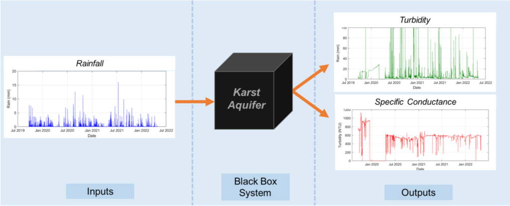
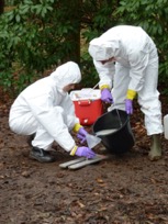
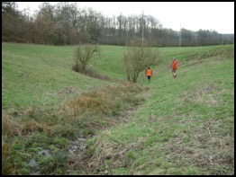
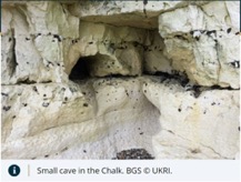
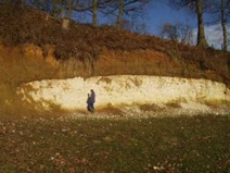
Figure 2: Upper panel: Borehole tracer injection and chalk stream sinkhole, southern England. Lower panel: Conduit in the Chalk and Paleogene Clays overlying Chalk (BGS, www.bgs.ac.uk).
The ultimate goal is to test the ability of indigenous tracers to provide a coherent understanding of fast pathways in chalk aquifers, and predict on contaminant transport, groundwater pollution vulnerability and therefore quality of abstracted groundwater and chalk-fed springs and streams.
Impact and expected outcomes
It is anticipated that this project will have a tangible impact on risk management strategies for Chalk catchments. The outputs of this research will be used for decision making by stakeholders in the UK such as the CASE partner company Affinity Water and the Environment Agency but also more widely. By conducting fieldwork (e.g., abstraction and stream sampling/lab fluorescence analysis plus deployment of in situ fluorescence loggers) and correlation analysis of data with rainfall, you will develop new analytical tools and approaches for characterisation of specific pathways and contaminant impacts, as well as providing information on aspects of functioning the specific chalk catchments investigated. The outputs of this investigation will be transferrable to other catchment systems and constitute the basis of a new generation of risk management approaches for water quality.
Training
You will be supervised by a multi-disciplinary group with a wide range of expertise including correlation analysis, tracer testing, and water quality management. They will join the Institute of Applied Geoscience (IAG) at the University of Leeds, a highly multi-disciplinary institute with a strong international profile, including around 75 PhD students and postdoctoral researchers of multiple nationalities. Given that the studentship will be delivered in collaboration with an industry partner (Affinity Water), you will be expected to spend a minimum of 3 months in a real-world setting at this company; fieldwork will also take place in Chiltern Hills, Hertfordshire.
You will work under the supervision of Prof. Jared West and Prof. Simon Bottrell within the Institute of Applied Geoscience in the School of Earth and Environment at the University of Leeds, with additional support from Dr Louise Maurice (British Geological Survey) and Dr Ilias Karapanos (CASE partner supervisor at Affinity Water). This project provides a high level of specialist scientific training in area including: (i) field and lab analysis of water quality indicators; (ii) tracer testing approaches and iii) correlation and spectral analysis of timeseries datasets. Co-supervision will involve regular online meetings with the BGS and CASE supervisors, plus two field seasons for geological and hydrogeological fieldwork. There is also a requirement to undertake a minimum 3-month duration internship at CASE partner organisation (Affinity Water) premises. Internships are likely to be undertaken early, as they provide opportunities to collate background information held by the partner, for example timeseries water quality data. You will have access to a broad spectrum of training workshops put on by the Faculty at Leeds that include an extensive range of training workshops in technical aspects, through to managing your degree, to preparing for your viva (http://www.emeskillstraining.leeds.ac.uk/).
Student profile
You will have a degree in Geoscience or Environmental Sciences with a strong quantitative background (includes Geophysics, Geology, Engineering Hydrology and related subjects, Environmental Science), the ability to undertake fieldwork and laboratory work to analyse water and sediment samples. You will need to undertake fieldwork in the field areas relevant to CASE partner (i.e. South East of England), such sample collection, deployment of field monitoring kit, and tracer testing, with support from the staff at BGS Wallingford and CASE partner staff.
For further information related to the project or any other specific questions concerning what the successful applicant will be expected to do and required educational background, please contact the lead supervisor. We encourage interested applicants to get in touch and arrange an informal online meeting to discuss details of the project prior to application.
References
Key Supervisor Publications
Agbotui, P. Y., West, L. J., & Bottrell, S. H. (2020). Characterisation of fractured carbonate aquifers using ambient borehole dilution tests. Journal of Hydrology, 589, 125191.
Allshorn SL; Bottrell SH; West LJ; Odling NE (2007) Rapid karstic bypass flow in the unsaturated zone of the Yorkshire chalk aquifer and implications for contaminant transport, In: Parise M; Gunn J (Ed) Natural and Anthropogenic Hazards in Karst Areas: Recognition, Analysis and Mitigation, Geological Society Special Publications, Geological Society of London, pp.111-122.
Maurice, L D, Atkinson, T A, Barker, J A, Bloomfield, J P, Farrant, A R, and Williams, A T. 2006. Karstic behaviour of groundwater in the English Chalk. Journal of Hydrology 330 53–62. 10.1016/j.jhydrol.2006.04.012
Maurice, L D, Atkinson, T C, Williams, A T, Barker, J, and Farrant, A R. 2010. Catchment scale tracer testing from karstic features in a porous limestone. Journal of Hydrology. 389 (1–2) 31–4. 10.1016/j.jhydrol.2010.05.019
Maurice, L D, Atkinson, T C, Barker, J, Williams, A T, and Gallagher, A. 2012. The nature and distribution of flowing features in a weakly karstified porous limestone aquifer. Journal of Hydrology. 438–439, 3–15. 10.1016/j.jhydrol.2011.11.050
Medici G, West LJ, Chapman PJ, Banwart SA. 2019. Prediction of contaminant transport in fractured carbonate aquifer-types; case study of the Permian Magnesian Limestone Group (NE England, UK). Environmental Science and Pollution Research. 26(24), pp. 24863-24884
Medici, G., & West, L. J. 2021. Groundwater flow velocities in karst aquifers; importance of spatial observation scale and hydraulic testing for contaminant transport prediction. Environmental Science and Pollution Research, 28(32), 43050-43063.
Other key references
Cook, S J, Fitzpatrick, C M, Burgess, W G, Lytton, L, Bishop, P, and Sage, R. 2012. Modelling the influence of solution-enhanced conduits on catchment-scale contaminant transport in the Hertfordshire Chalk Aquifer. In: Groundwater resources modelling a case study from the UK, Geological Society Special Publication 364, p. 205- 225
El Janyani, S., Dupont, J.P., Massei, N., Slimani, S. and Dörfliger, N., 2014. Hydrological role of karst in the Chalk aquifer of Upper Normandy, France. Hydrogeology Journal, 22(3), pp.663-677.
Massei, N., Lacroix, M., Wang, H. Q., & Dupont, J. P. (2002). Transport of particulate material and dissolved tracer in a highly permeable porous medium: comparison of the transfer parameters. Journal of Contaminant Hydrology, 57(1-2), 21-39.
Massei, N., Dupont, J. P., Mahler, B. J., Laignel, B., Fournier, M., Valdes, D., & Ogier, S. (2006). Investigating transport properties and turbidity dynamics of a karst aquifer using correlation, spectral, and wavelet analyses. Journal of hydrology, 329(1-2), 244-257.