
How do complex fault geometries influence earthquake cycle deformation?
This exciting project aims to understand how complicated fault geometries influence earthquake nucleation and recurrence. You will combine field work, lab analyses, and seismology to investigate fault slip patterns on multiple scales in time and space.
Heterogeneities in fault system geometries may strongly influence earthquake nucleation and recurrence (Cowie et al., 2012; Dieterich and Richards-Dinger, 2010; Walters et al., 2018). In particular, normal faults display complex geometries due to the mechanisms by which they evolve and grow, and the relationship between repeated faulting and the growth of topography in the footwall (Ciftci and Bozkurt, 2007; DuRoss et al., 2019). Fault geometry complexities such as segmentation, relays, and branches can act as persistent barriers to rupture, but might also invoke heterogeneities in stress and strength that can influence the size and frequency distributions of earthquake rupture (Goebel et al., 2015). In this project you will characterise fault behaviour across different scales in time and space to better quantify how complex geometries may influence patterns of earthquake recurrence.
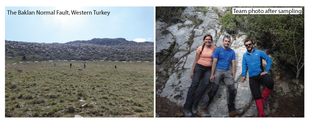
Faults in the V-shaped Dinar-Baklan basin in western Turkey intersect at a perpendicular angle at the fault terminations. There are three main faults accommodating extension across the region, including the Dinar fault that ruptured in an Ms 6.1 eathquake on the 1 October, 1995 (Altunel et al., 1999; Eyidogan and Barka, 1996). Localities have been identified to collect samples to measure the Quaternary fault slip rate, and how it varies through time, on each fault using cosmogenic isotope analyses. Cosmogenic isotopes are a Quaternary dating technique that quantifies how earthquakes have displaced the ground surface over multiple earthquake cycles and thousands of years (Goodall et al., 2021; Schlagenhauf et al., 2010). Results from these analyses will illuminate how the fault slip rate has varied over time, and whether these three faults have similar patterns of displacement.
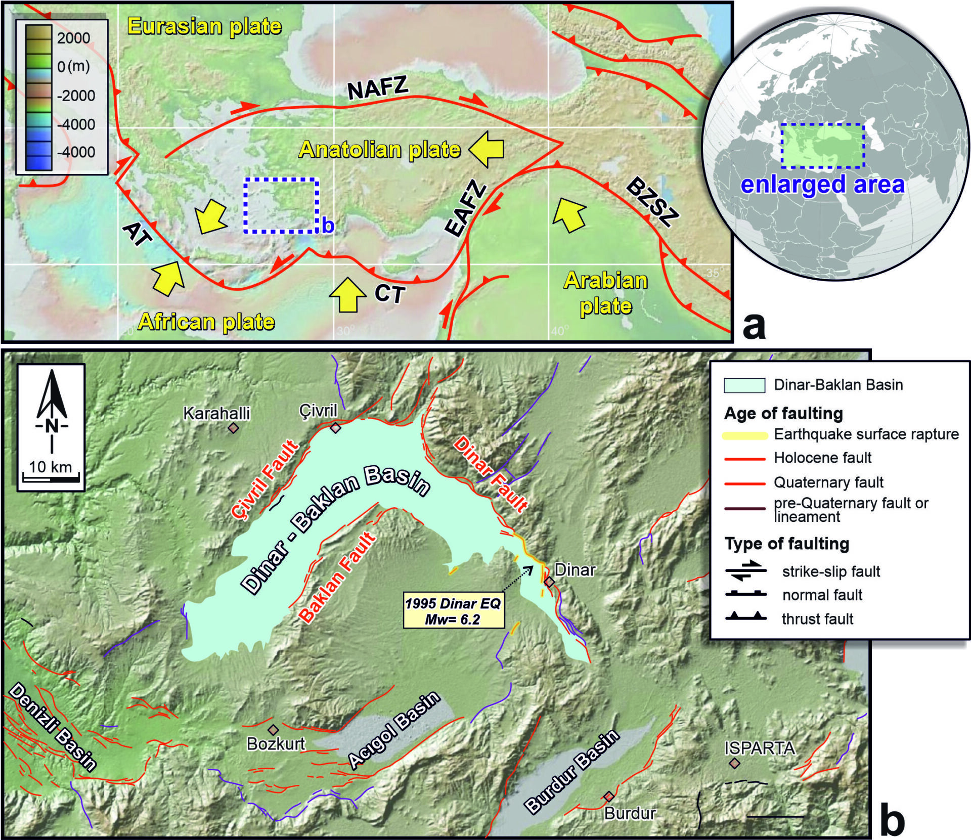
Deformation across western Turkey is accommodated on a complicated network of large normal faults with variable orientations (Bozkurt, 2003; Bozkurt and Sozbilir, 2004; Uzel, 2016). Rapid extension is distributed across the large network of normal faults, but exactly how each fault contributes, and whether there are major unknown faults that also may be important, is still unknown (e.g. Nissen et al., 2022). This project will aim to determine the precise geometry of the Dinar-Baklan basin faults at depth using geological mapping, cross sections, and seismology. The surface expression of the faults will also be mapped in detail using Terrestrial Laser Scanning (TLS), UAV – RS, and field mapping to characterise which aspect of geometry are likely to be important at depth. Further seismological observations covering western Turkey will aim to quantify characteristics of faulting (b-values, empirical density distributions), which will help to understand how regional deformation varies in space and time.
Ultimately, regional earthquake statistics can be used to conduct physics-based earthquake models that can be incorporated into statistically based earthquake hazard models (Shaw et al., 2018). This project aims to gain a better understanding of how complex faulting may influence the pattern of earthquakes across western Turkey, and has the potential for significant scientific and human impact.
Objectives
- Determine detailed fault slip rates on three faults in western Turkey using cosmogenic isotope analyses on bedrock fault scarps (Cowie et al., 2017; Goodall et al., 2021). You will conduct fieldwork to collect samples from sites identified previously and conduct detailed field-based surveys of the sites (e.g. using Terrestrial Laser Scanning, TL; Bubeck et al., 2015). You will process the samples in the lab, analyse the results, and model the data using Bayesian MCMC methods to determine time-variable fault slip rates for each fault.
- Investigate the structure of the Dinar – Baklan basin at depth using field based geological mapping, cross sections, and available seismological data. Combined with fault slip rate data, you will aim to better understand how cross-cutting basins evolve and interact at depth. You will investigate whether there are major barriers to rupture of these complex faults, and there is scope to conduct rupture modelling to determine how rupture scenarios might evolve over multiple earthquake cycles on intersecting faults.
- Investigate the seismological characteristics of normal faults across western Turkey to quantify earthquake statistics for the complex network of faults that span this region . Depending on your interests, you may further investigate fault properties by investigating paleostress indicators and fault surface roughness.
Applicant Background
This project is interdisciplinary across earth sciences and can be tailored to your interests. It suits candidates with a background in geology, geophysics, or physical geography and an interest in earthquakes. You may chose to focus on one or many of the different aspects of this project – from geochemistry and Quaternary dating to geophysics and seismology. We encourage applicants from all backgrounds.
References
Altunel, E., Barka, A., and Akyuz, S., 1999, Palaeoseismicity of the Dinar fault, SW Turkey: Terra Nova, v. 11, p. 297-302.
Bozkurt, E., 2003, Origin of NE-trending basins in western Turkey: Geodinamica Acta, v. 16, p. 61-81.
Bozkurt, E., and Sozbilir, H., 2004, Tectonic evolution of the Gediz Graben: field evidence for an episodic, two-stage extension in western Turkey: Geological Magazine, v. 141, no. 1, p. 63-79.
Bubeck, A., Wilkinson, M., Roberts, G. P., Cowie, P. A., McCaffrey, K. J. W., Phillips, R. J., and Sammonds, P., 2015, The tectonic geomorphology of bedrock scarps on active normal faults in the Italian Apennines mapped using combined ground penetrating radar and terrestrial laser scanning: Geomorphology, v. 237, p. 38-51.
Ciftci, N. B., and Bozkurt, E., 2007, Anomalous stress field and active breaching at relay ramps: A field example from Gediz Graben, SW Turkey: Geological Magazine, v. 144, p. 687-699.
Cowie, P. A., Phillips, R. J., Roberts, G. P., McCaffrey, K. J. W., Zijerveld, L. J. J., Gregory, L. C., Faure Walker, J., Wedmore, L. N. J., Dunai, T. J., Binnie, S. A., Freeman, S. P. H. T., Wilcken, K., Shanks, R. P., Huismans, R. S., Papanikolaou, I., Michetti, A. M., and Wilkinson, M., 2017, Orogen-scale uplift in the central Italian Apennines drives episodic behaviour of earthquake faults: Scientific Reports, v. 7:44858.
Cowie, P. A., Roberts, G. P., Bull, J. M., and Visini, F., 2012, Relationships between fault geometry, slip rate variability and earthquake recurrence in extensional settings: Geophysical Journal International.
Dieterich, J. H., and Richards-Dinger, K. B., 2010, Earthquake Reccurence in Simulated Fault Systems: Pure Appl. Geophys., v. 167, p. 1087–1104.
DuRoss, C. B., Bunds, M. P., Gold, R. D., Briggs, R. W., Reitman, N. G., Personius, S. F., and Toke, N. A., 2019, Variable normal-fault rupture behavior, northern Lost River fault zone, Idaho, USA: Geosphere, v. 15, no. 6, p. 1869-1892.
Eyidogan, H., and Barka, A., 1996, The 1 October 1995 Dinar earthquake, SW Turkey: Terra Nova, v. 8, p. 479-485.
Goebel, T. H. W., Sammis, C. G., Becker, T. W., Dresen, G., and Schorlemmer, D., 2015, A comparison of seismicity characteristics and fault structure between stick-slip experiments and nature: Pure Appl. Geophys., v. 172, p. 2247-2264.
Goodall, H. J., Gregory, L. C., Wedmore, L. N. J., McCaffrey, K. J. W., Amey, R. M. J., Roberts, G. P., Shanks, R. P., Phillips, R. J., and Hooper, A., 2021, Determining histories of slip on normal faults with bedrock scarps using cosmogenic nuclide exposure data: Tectonics, v. 40, p. e2020TC006457.
Nissen, E., Cambaz, M. D., Gaudreau, E., Howell, A., Karasozen, E., and Savidge, E., 2022, A reappraisal of active tectonics along the Fethiye-Burdur trend, southwestern Turkey: Geophysical Journal International, v. 230, p. 1030-1051.
Schlagenhauf, A., Gaudemer, Y., Benedetti, L., Manighetti, I., Palumbo, L., Schimmelpfennig, I., Finkel, R., and Pou, K., 2010, Using in situ Chlorine-36 cosmonuclide to recover past earthquake histories on limestone normal fault scarps: a reappraisal of methodology and interpretations: Geophysical Journal International.
Shaw, B. E., Milner, K. R., Field, E. H., Richards-Dinger, K. B., Gilchrist, J. J., Dieterich, J. H., and Jordan, T. H., 2018, A physics-based earthquake simulator replicates seismic hazard statistics across California: Science Advances, v. 4, p. eaau0688.
Uzel, B., 2016, Field evidence for normal fault linkage and relay ramp evolution: the Kirkagac fault zone, western Anatolia (Turkey): Geodinamica Acta, v. 28, no. 4, p. 311-327.
Walters, R. J., Gregory, L. C., Wedmore, L. N. J., Craig, T. J., McCaffrey, K. J. W., Wilkinson, M., Chen, J., Li, Z., Elliott, J. R., Goodall, H., Iezzi, F., Livio, F., Michetti, A. M., Roberts, G., and Vittori, E., 2018, Dual control of fault intersections on stop-start rupture in the 2016 Central Italy seismic sequence: Earth and Planetary Science Letters, v. 500, p. 1-14.